
 |
| Chatham Bay |
Chatham Bay, Union is remote. The only landward approach is via a footpath down the steep hillside from a road that follows the contour more than halfway up the rocky mountain sides, a loop of concrete leading to the settlements on the flatter southern side of this triangular island but not descending into Chatham. Usual access even for the small community living or working here is by sea. It being the tail end of an extremely dry dry season the rainforest is mostly leafless grey, and where it is more open the grass burnt brown. Frigate Birds wheel on the updrafts above the steep cliffs, Laughing Gulls chase fish shoals across the bay and sunsets are spectacular with nothing to obstruct the view across the ocean to the western horizon. The few fishermen lay their nets perpendicular to the reef on the north side from wooden rowing boats early in the morning gathering them in as the yachties wake up. The snorkelling here was amazing – swimming with tens of thousands of silver fish slightly longer than a hand plus closer in, all the usual gaily coloured reef residents busy feeding around the coral. Kevin got a bit of a shock when a huge barracuda cruised through snacking its way through the fish shoal during our first afternoon; it was the largest he had ever seen so close to.
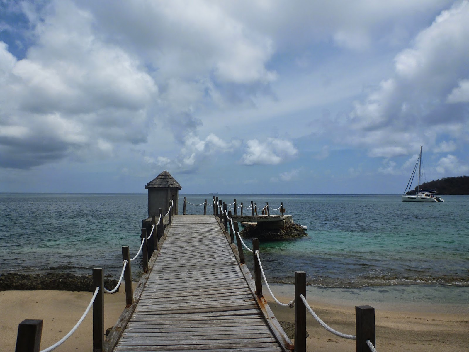 |
| Aqua’s landing jetty |
Along the shore are seven bars, yes seven! One “Aqua” is a bit more up market with two thatched roof open sided buildings that wouldn’t look out if place at a top resort hotel, apparently their custom is the cruise liners that call in during the high season. They even have a few palm trees rather than the scrubby manicheel trees that fringe most of the beach. Despite or perhaps because of the remoteness all the bars charge top whack for beer and soft drinks; we were quoted $10EC by bar staff when they came alongside to tout their place, almost twice the price elsewhere. We stuck to Temptress’ stores deciding we could do without wifi (our usual reason to seek out a bar or cafe) for a few days. There is no mobile signal here either so this place really is isolated. The bar music was loud however the local radio station which most seemed to re-broadcast is actually quite good and as the shacks were mainly open only through the afternoon until shortly after sunset not as intrusive as it has been elsewhere.
 |
| Temptress at anchor, Chatham Bay |
After three nights with only a handful of yachts for company in the wide expanse of Chatham Bay the gusty squalls were beginning to get on our nerves as they howled down from the tree clad mountains completely unpredictable in direction setting all the boats swinging roughly on their anchors. Temptress would swerve sharply one way and then be thrown the other way a few seconds later by another gust repeatedly only to settle quietly for minutes or even hours at a time before being battered again. Lovely though the bay is it was time to move on.
Each time we plan to up anchor and sail to another port even if like now it is just the other side of the island a certain amount of preparation has to be made. Of first importance is the nav (navigation or planning the journey) – any trip has like a good story has three parts; a beginning, a middle and an end. The beginning is how to extract Temptress out of her current anchorage – obstacles like rocks and reefs to avoid, where the shallow bits lie, where are neighbouring boats, what state is the sea in and which way is the wind gusting – this fiddly stuff is usually known as pilotage and can only be done with a mark one eyeball after a good read of the chart.
 |
| Silly hat time |
The middle bit is far easier – the course(s) to steer to get to our intended destination given the current state of the wind and tide, avoiding any land which may lie between us and our destination. The end part is a reverse of the beginning but for a different place. For this last spot of pilotage our usual practise since arriving here has been to select the right page in Chris Doyle’s pilot guide to the Windward Islands where there is either a line drawing or an aerial photo showing the reefs and rocky bits as well as the depths of water (the latter in feet so some quick maths has to be done as Temptress measures stuff in metres). For the whole trip the First Mate is in charge of plotting waypoints using the electronic chart software on the boats dedicated laptop to make a route. Zooming in close on the laptop gives a reasonably clear idea of where things are, but bear in mind that some of the surveying that contributed to these charts is older and sometimes untouched since Captain James Cook’s original surveys. It is safer to assume charts are less accurate than GPS positions meaning when close to land, eyeball navigation with a paper chart or the pilot guide on deck as a reference is less stressful than rigorously sticking to the waypoints especially as reefs are living things and may expand beyond channel markers etc. If the water nearby starts to turn paler blue or even brown or there are breakers ahead you know it is becoming shallow, possibly too shallow; time to alter course and be elsewhere.
 |
| Temptress is a sea of blue |
The electronic route is checked through for any gotchas and will be “activated” before we depart so that information related to the next waypoint is broadcast to a display on deck; a step the first mate often forgets until we are actually underway (doh!). Once enroute Temptress’ crew will keep an eye on the bearing to waypoint or BTW (pronounced but-a-wuh by Temptress’ crew) compared to our heading (HDG) and actual course over the ground (COG). Unlike a car on solid ground a boat does not necessarily, in fact rarely does move in the direction she is heading (ie where the bow is pointing) as the body of water the boat is floating in is often on the move as well through tides or currents. In this part of the world the movement is mainly due to an ocean current flowing east to west across the Atlantic that eventually curls around the Caribbean to become the Gulf Stream that warms the British Isles. With some yachts the wind may also cause a sideways slippage called leeway but for Temptress even beating to windward that effect is minimal and can be ignored for the most part. Therefore underway we decide whether or not to alter the direction we are steering or heading based on the difference between BTW (ie where we want to be) and COG (ie the actual direction we are traveling) plus if adjacent to something big and solid like an island just how close we can be! For example if the tide or current is roughly at right angles to our heading for six hours then changes to run in the opposite direction for six hours and we assume there is nothing to hit we can just go with the flow; being swept up the English Channel and then back down again over a 12 hour period, our BTW will change but our constant heading (known when planning as the course to steer) will ultimately ensure that we make our destination on the other side. In the Caribbean many islands, rock outcrops and reefs impact the current or simply get between Temptress and her destination so a keener watch is needed. Frequent small adjustments tend to be the order of the day.
 |
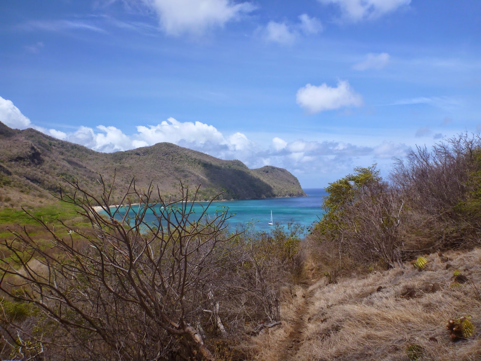
| View from the hills above Chatham across to Mayreau and Canouan beyond |
Before we can actually weigh anchor there is stuff to stow on away like the dinghy along with its outboard engine, fuel can and anchor. Our practise is to only tow the dinghy if going a few hundred yards as, being our sole link to the shore from an anchorage, we daren’t risk its loss, sinking or terminal damage. Over the fourteen years we’ve owned Temptress a routine has established itself. The skipper sorts out the dinghy and prepares on deck by removing the sailcover, the anchor light and anything else not needed on passage (shoes, cushions, empty mugs, books/kindles – the usual paraphernalia found outdoors after a few days of sunshine). Down below the first mate ensures anything on the galley work surfaces (dirty dishes are washed), saloon table (pc’s, sunglasses, books, shells) or round the heads sink (shampoo, showergel, toothpaste etc) is put back into lockers , the long saloon/galley rug is rolled up as it tends to slip and slide awkwardly underway. Boat Ted assumes his safe position at sea tucked in the top of a basket so he can’t tumble to the floor to roll around the saloon. The fruit bowl, currently full of ripening bananas and mangoes is balanced on top of the fruit and veg in the galley cool box.
A run through the boat from front to back is made checking for remaining items that could fall off/down, hatches and portholes are closed, winch handles fetched up to the cockpit. The security bars for the main hatch are handed down and carefully placed on a bunk to be held in place by a leecloth and some cushions; far quicker than trying to bury them in their home at the bottom of a cockpit locker for a short sail. The kettle is filled, two mugs sit ready in a saucepan for our habitual cuppa once underway and the gimbal on the stove is unlocked so these items stay horizontal regardless of the boat’s movements. The instruments are turned on and the prepared route activated. Finally some half an hour or so later Temptress is ready for sea. In an emergency we would simply close the hatches and leave following the reverse of our route in, our safety and that of the boat being more important than that of our belongings scattered about and in fact we are usually quite good about putting stuff back in its place after use or prior to sleeping especially if the weather forecast is not pretty.
 |
| Snorkelling off Clifton, Union Island, SVG |
For Saturday’s short trip to the other side of Union Island we were left wondering whether all this effort was worth it. The sail cover remained in place; we needed to charge the batteries for an hour and the motor to Clifton from Chatham would be less than that. The bay we were departing from is wide and apart from a reef to its north-side obstacle free. Away from the gusts in Chatham Bay the wind was light and the seas almost flat, an unusual experience for us since arriving in the Windward Isles. Around a steep-to headland quaintly called Miss Irene Point that marks the southern edge of the bay, past Frigate Island where we anchored overnight a few weeks ago avoiding Lagoon reef which we know expends well to the south and east. Then keeping clear of the rocks well marked with a beacon off to starboard closer to Palm Island, we picked our way north between the reefs off Clifton Town to anchor in 7 metres of clear blue behind the easternmost Newlands Reef.
With a cooling breeze gently blowing from the east Temptress sits comfortably between the reefs in water that is amazing shades of blue as it shelves gently upwards to the reef, and far less crowded than on our previous visit before Easter. Sea so clear that when the sun was higher we could see the rock strewn sandy bottom and a little shoal of tiny fish being chased by a small tuna! Happy Island is off our bow, the occasional light aircraft lands at the airport to our left and once the shops close for the weekend on Saturday lunchtime the small town is devoid of crowds. This is an idyllic place to be, so of course the effort involved for such a short hop was worth it!
